Annapurna Circuit Trek
Manang · Gandaki Province
Video Tour — Coming Soon
Immersive short films from Yatribhet's field team. Drone footage, ground level walkthroughs, and real traveler stories will appear here.
Annapurna Circuit Trek
"The Annapurna Circuit Trek, located in Nepal’s Manang District, is one of the world’s most famous long-distance treks, about 170–200 km over 14–20 days (depending on the trekking speed and acclimatization needs). It circles the magnificent Annapurna Mountain Range. The Annapurna Circuit is not a straight or consistent trek; daily distances vary depending on the terrain and altitude. The lower sections are generally easier and allow for longer walks, while the higher regions, especially near Thorong La Pass, are more challenging and adventurous and sometimes steep, requiring shorter, more careful trekking days. Acclimatization stops, such as in Manang, are essential to prevent mountain sickness, as they help trekkers adjust to the high altitude and reduce the risk of altitude-related illnesses. Because of its dynamic and adventurous nature, the Annapurna Circuit Trek attracts and is enjoyed by many people. Key Feature of the Annapurna Circuit Trek: Thorong La Pass: Thorong La Pass, at approximately 5,416 meters, is the highest point on the Annapurna Circuit. It lies between the world’s 7th highest mountain, Dhaulagiri, and the 10th highest, Annapurna, offering trekkers breathtaking views of these towering peaks. It is one of the toughest and highest trekking passes in the world, known for being challenging and potentially dangerous due to its high altitude, steep slopes, and extreme weather conditions. Acclimatization Hike in Manang: At 3,540 meters above sea level, the Manang Acclimatization Day is an important rest day to help trekkers adjust to the high altitude. Trekkers can enjoy short hikes to nearby viewpoints, such as Gangapurna Lake or the Manang Valley Viewpoint, both offering stunning scenery while supporting acclimatization. Explore the Manang Valley, their culture, and food. Diverse Landscapes: The Annapurna Circuit features a wide variety of landscapes, from lush valleys and vibrant rhododendron forests to dramatic high-altitude scenery with glaciers and snow-capped peaks. Trekkers are treated to stunning views every day. Views of the Annapurna Mountains: Throughout the trek, trekkers are surrounded by the stunning Annapurna mountain range, which includes Annapurna I, the tenth-highest peak in the world. As you make your way around the circuit, you can admire these majestic peaks from many different perspectives. Marsyangdi River and Water Features: The Marsyangdi River flows through much of the Annapurna Circuit, offering stunning riverside scenery. Its turquoise waters pass valleys, forests, and villages, creating a peaceful backdrop. Trekkers also encounter streams, waterfalls, and small glacial lakes along the route. Muktinath (3,800m) and Monasteries: From Thorong La Pass, trekkers reach Muktinath, a sacred site for Hindus and Buddhists. Visit the Muktinath Temple and observe the monasteries along the Annapurna Circuit, experiencing the area’s unique religious and cultural atmosphere. Sunrise at Poon Hill (3,210m): Enjoy a stunning sunrise over the Annapurna mountains. Warm clothing is recommended for the early-morning hike. Ideal Season for Annapurna Circuit: Autumn (September to November): Clear skies, stable weather, and stunning mountain views. Spring (March to May): Moderate temperatures, rhododendrons in full bloom, and good visibility. Also a great time for scenery and flowers. Essential tips for trekking the Annapurna Circuit: Acclimatize properly (rest days in Manang) Best time to trek: Autumn (Sep–Nov) and Spring (Mar–May) Start early, especially for Thorong La Pass. Pack layers for varying temperatures. Stay hydrated. Wear sturdy trekking shoes. Carry enough cash (ATMs are limited). Maintain moderate physical fitness. Eat light and digestible food. First-aid kit and carry essential items such as sunglasses, gloves, bandages, painkillers, altitude sickness medication, and any personal medications. It’s important to be prepared for minor injuries, colds, and high-altitude conditions. "
Details & Guides
Location
Travel Routes
Click any stop below to pin it on the map
Kathmandu (1400m/4600ft) to Besisahar
Drive from Kathmandu to Besisahar, which takes about 7-8 hours by bus or 6-7 hours by jeep, with the jeep being the better option. Leaving early in the morning helps avoid traffic jams and ensures you arrive on time to rest. Overnight stay in Besisahar.
Besisahar to Dharapani (6,200 ft /1,860 m)
Drive from Besisahar to Dharapani by jeep, which takes about 3–4 hours, covering approximately 30–35 km via Bulbule, Jagat, and Tal, following the scenic Marsyangdi River, and stay overnight in Dharapani.
Dharapani to Chame (8,890 ft/2,610 m)
From Dharapani, the trek officially begins towards Chame, taking about 6 hours and covering around 15.5 km (9.6 miles) along the scenic Marsyangdi River. While some people choose to drive up to Manang and start trekking from there, this remains an optional choice. Trekking from Besisahar is often preferred, as it allows better acclimatization, helping trekkers gradually adjust to the altitude while resting along the way. In Chame, which is the headquarters of Manang, trekkers can explore the local area. Overnight stay in Chame.
Chame to Upper Pisang (10,826ft / 3,300m)
Trek takes about 5 hours and covers around 14-15 km. Trekkers can enjoy stunning views of Annapurna II. Along the way, you can try local organic apples and apple products such as apple donuts, muffins, juice, and pie. You can also explore monasteries along the trekking route. Overnight stay in Upper Pisang.
Upper Pisang to Manang (3,540m / 11,300ft)
Trek from Upper Pisang to Manang takes 6 hours and cover around 16 km. Overnight stay in Manang.
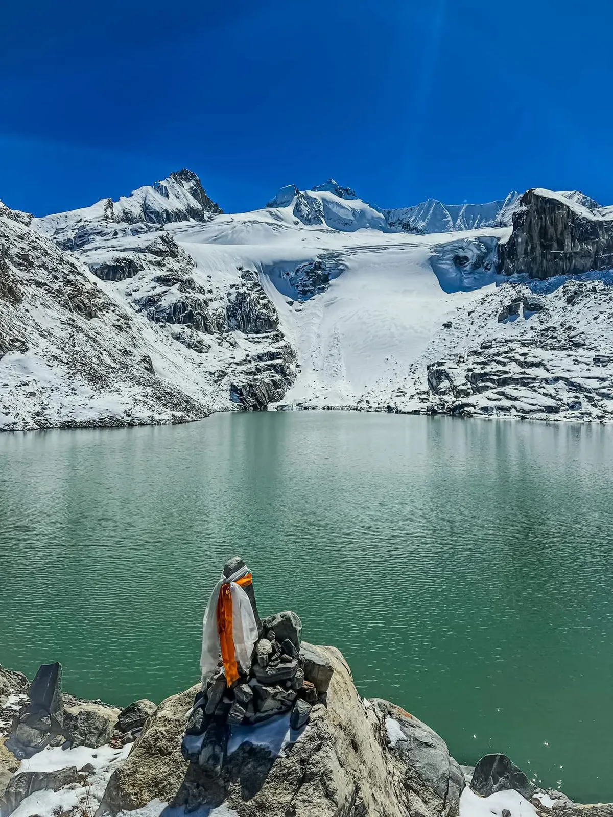
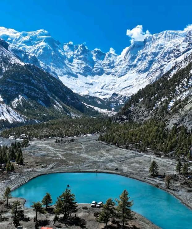
Rest & acclimatization day at Manang (3,519 m) & visit Gangapurna Lake ( 3,800m)
Manang is one of the best places for rest and acclimatization during the Annapurna Circuit trek, especially after about five days of continuous travel and hiking. It is a crucial stop that helps your body adjust to higher altitudes and reduces the risk of altitude sickness. Instead of taking complete rest, short hikes are highly recommended, such as a two-hour hike to Gangapurna Lake (3,888 m), which is about 600-700m from Manang, along with visits to Bhojo Gumba and nearby viewpoints that further support acclimatization. While staying in Manang, you can also explore the unique culture and lifestyle of the local community. For successful acclimatization, it is important to stay well hydrated by drinking water regularly, eat light and easily digestible food, avoid meat if possible, and focus on carbohydrate-rich meals for energy. Wearing layered clothing helps manage temperature changes, and carrying a water bottle at all times during hikes is essential. Moving slowly, staying active with short hikes, and listening to your body are key practices, and an overnight stay in Manang is highly recommended for proper acclimatization.
Manang - Tilicho Base Camp
The trek from Manang to Tilicho Base Camp takes 5–7 hours, covering 11–13 km. The trail passes landslide-prone areas, so trekkers need to walk carefully. Overnight stay in Tilicho Base Camp.
Tilicho Base Camp (4,150 m) to Tilicho Lake (4,919 m) to Shree Kharka (4,080 )
The trek from Tilicho Base Camp to Tilicho Lake and then back to Shree Kharka takes about 6 hours, covering 10–12 km. This is the hardest part of the Tilicho trail, with steep climbs to reach the lake. Explore Tilicho Lake, then return to Shree Kharka. Overnight stay in Shree Kharka.
Shree Kharka (4,080 m) to Yak Kharka (4,050 m)
The trek from Shree Kharka to Yak Kharka takes about 6 hours, covering 10–11 km. Overnight stay in Yak Kharka.
Yak Kharka to Thorong Phedi or High Camp (4,525 m / 14,525 ft)
The trek from Yak Kharka to Thorong Phedi or High Camp is about 8.5 km (5.3 miles) and takes 4-5 hour. The trail climbs uphill, passing through landslide-prone areas, and requires extra caution in some dangerous sections. Thorong Phedi is the last stop before Thorong La Pass. On this day, after reaching Thorong Phedi, you can take a short hike up to the viewpoint to see the trail and surrounding scenery, because you’ll have to start very early the next morning, around 3-4 AM, to cross Thorong La Pass before sunrise. Enjoye the panoramic views. Overnight stay in Thorang Phedi.
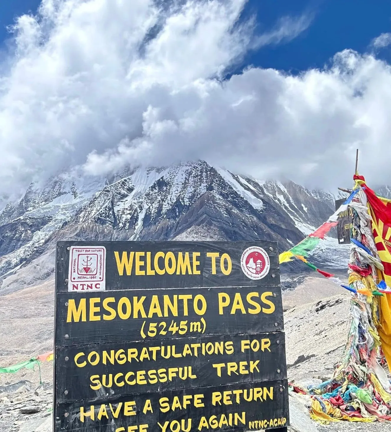
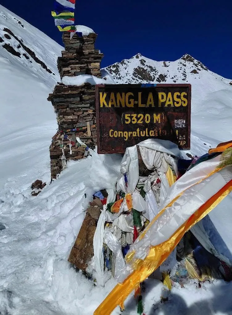
Thorang Phedi to Thorangala pass (5,416m/17,769 ft) to Muktinath (3,710 m)
The trek from Thorong Phedi to Thorong La Pass is the toughest part of the Annapurna Circuit and starts very early, around 3–4 AM, to avoid the dangers of hiking later in the day. The climb is steep and high-altitude (about 4,525 – 5,416 m) with possible snow and ice, so careful pacing and acclimatization are essential. The view from the pass is stunning and unforgettable. After crossing Thorong La Pass, the trail descends to Muktinath, taking a total of about 8 hours. Trekkers can explore Nepal’s famous Muktinath Temple after the trek. It’s a sacred site for both Hindus and Buddhists, known for its 108 water spouts, natural spring, and panoramic mountain views. The trek covers approximately 15.6 km (9.6 miles).
Muktinath (3,710 m) to Marpha (2,650 m)
The trek from Muktinath to Marpha via Jomsom takes 6-7 hours by hike or 2-2.4 hours by jeep, covering 21–30 km. Overnight stay in Marpha.
Marpha (2,650 m) to Kalopani (2,480 m)
The trek from Marpha to Kalopani takes 5–6 hours, covering 18–20 km. Enjoy the views of Dhaulagiri and Nilgiri. Overnight stay in Kalopani.
Kalopani (2,480 m) to Tatopani (1,190 m)
The trek from Kalopani to Tatopani takes 6–7 hours, covering 16 km. The trail passes through villages and jeep roads, with the chance to experience natural hot springs. Overnight stay in Tatopani.
Tatopani (1,190 m) to Ghorepani (2,750 m)
The trek from Tatopani to Ghorepani takes 7–8 hours, covering 15–26 km. Overnight stay in Ghorepani.
Ghorepani (2,750 m) to Tadapani (2,630 m)
The trek from Ghorepani to Tadapani takes 5–6 hours, covering 10–11 km. From Ghorepani, trekkers can also hike to Poon Hill for sunrise views. Overnight stay in Tadapani.
Tadapani (2,630 m) to Chomrong (2,170 m)
The trail continues from Tadapani to Chomrong, taking about 6 hours and covering approximately 11 km. The route passes through forests and rivers. Overnight stay in Chomrong
Chomrong (2,170 m) to Himalaya (2,920 m)
The trek from Chomrong to Himalaya takes 6–7 hours, covering 14 km. The trail passes through forests and rocky terrain. Overnight stay in the Himalaya.
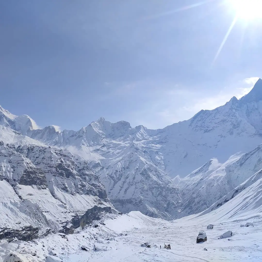
Himalaya (2,920 m) to Annapurna Base Camp (ABC, 4,130 m)
The trek from Himalaya to ABC takes 6–7 hours, covering 10–11 km, crossing through MBC Deurali along the way. Enjoy the breathtaking views at Annapurna Base Camp, surrounded by towering peaks like Annapurna I, Annapurna South, Machapuchare, Hiunchuli, and Gangapurna, all set in serene natural beauty. An overnight stay is at ABC.
Annapurna Base Camp (ABC, 4,130 m) to Bamboo (2,310 m)
The trek from ABC to Bamboo takes 6–7 hours, covering approximately 15 km. Overnight stay in Bamboo.
Bamboo (2,310 m) to Pokhara (820 m)
The trek from Bamboo to Jhinu Danda takes 5–6 hours, covering 20–23 km. From Jhinu Danda, you can drive 2–3 hours (60–70 km) to reach Pokhara.
Pokhara to Kathmandu
The road journey from Pokhara back to Kathmandu takes 6–8 hours, covering around 200 km, or you can return by flight in about 30 minutes.
Kathmandu Metropolitan City, Kathmandu, Bagamati Province, Nepal
DestinationActual trail conditions may vary. Always rely on local guides for real-time route safety.
Reviews
Available Amenities
No amenities information available for this place yet.